The project takes place in Istanbul, especially in Fatih. Fatih, the area in which we intervene, is a central district of Istanbul known as the “historical peninsula”, surrounded by the Theodosian walls and the sea from three directions. Given its historical background, Fatih is the most touristic part of Istanbul.
We focus on an area located beside the Theodosian walls, which distinguish the old from the new city. The whole area consists of many neighborhoods. Each one of them has its own character.
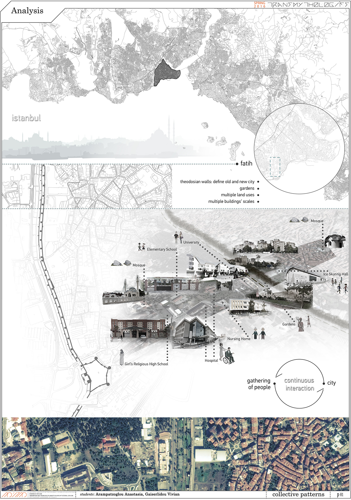
In the video we can see that as the city has been expanding over the centuries, the green spaces have been decreasing, which is the main characteristic that we observed in this area. Different gatherings of people form the city while the city forms the gatherings of people. Therefore there is a cycle of continuous interaction between humans and the environment. As a result of this cycle, we observe multiple land uses and building scales in our study area. Some of these uses are: education buildings, health buildings, worship buildings, recreation, housing and finally the gardens, that grow on the Theodosian walls.

In order to understand the study area, we analyzed the different layers of the city, which are:
- topography: The terrain is not very intense.
- road network: Inside the Theodosian walls there is an organic development of the urban fabric, while outside them, where there is the more recent part of the peninsula, the urban fabric is more organized.
- buildings: In correlation with the road network, inside the urban fabric is dense creating a “sense of neighborhood”, in contrast with the recent part.
- building scale: The scale depends on the use. In general, the public buildings are of large scale as opposed to the housing.
Finally, we focus on the open green spaces of the city, which constitute the larger part of the study area. However, they are not vital elements in the urban fabric.
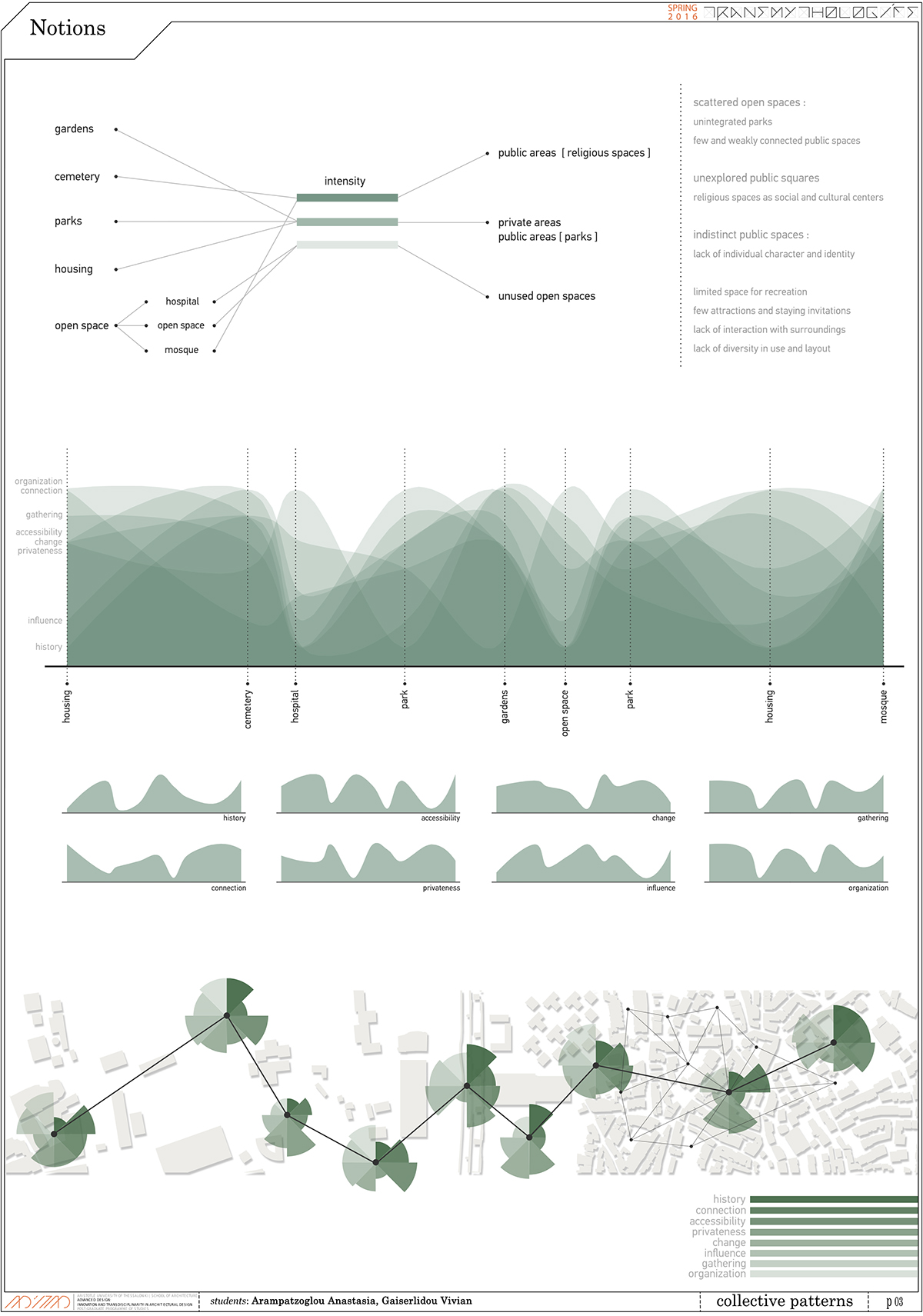
More specifically, these open green spaces are the gardens, the cemetery, parks, housing open space, open space with no use.
We tried to correlate the open space types with the notions of history, connection, accessibility, privacy, change, influence, gathering and organization, in order to understand their qualities and how the intruder experiences them.
At another level we correlate them with some tangible and intangible elements, such as light-shadow, texture, views, flows and geometry. For example, light and shadows are more dense in the cemetery, while textures are richer in the gardens.
In the middle diagram, we can see the correlation between open space types and notions. On the horizontal axis we can see the open space types, as they are located on site, and on the vertical axis the notions. Every space type has different intensity to each notion.
All the notion diagrams are placed together and also on a new map diagram, in order for the qualities of each space type separately to be appreciated. As we can see, there are some space types which have high intensity and others with low intensity.
From the diagrams, we observe that the open green spaces with high intensity are public areas, mostly worship spaces, spaces with low intensity are the unused open spaces and the rest are private areas or public areas, such as parks.
After the analysis, the current situation in the study area is that the open spaces are scattered and unintegrated, the public squares are unexplored, while the worship spaces are used as social and cultural poles. Also, it is important that there is lack of character and identity in public spaces.


Our intention and respective scenario is the redefinition and the re-appropriation of urban open space creating an area of meeting and exchange for the inhabitants. Our goal is a transition
- from individuality to collectivity,
- from introversion and no-man's-land, which characterize the introverted society of
Istanbul to extraversion and connectivity,
in order to create a new public life pattern, a new way to experience public space shaped and acceptable from the local society.
In these diagrams, we can see the individuality and how to reach collectivity through the creation of networks and connections between them. On the other diagram we can see the process of the previous diagram developing on layers.
Returning to the cycle of continuous interaction between humans and environment, the behavior is placed in the center of a circle, which is affected by the structure and agency. By structure we define the social structure and socialization. There are also some elements of influence, such as the social class, religion, gender, ethnicity, customs, which determine or limit an agent and its decisions. As agency we define the autonomy, in other words the capacity to act independently and make free choices.
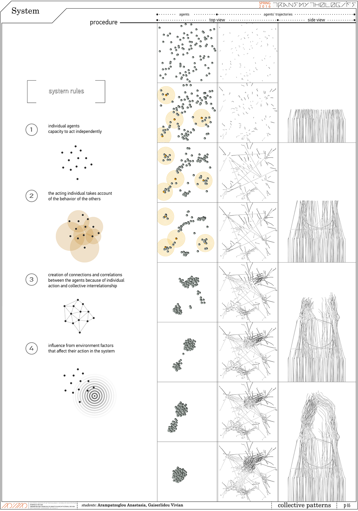
Therefore, we study a system that examines behaviors that explain how from the agents’ individual action, collective behaviors are formed through social structure.
This system is defined by some basic rules.
- First of all, the individual agents have the capacity to act independently.
- Also, the acting individual takes account of the behavior of the others.
- Another rule is the creation of connections and correlations between the agents because of individual action and collective interrelations.
- And the last one is the agent’s influence from environmental factors that affect their action in the system.
The previous theoretical diagrams of individuality to collectivity turn into a practical procedure. The agents’ system develops according to the system rules and we record the agents’ trajectories, in order to understand the densities and gatherings of the system on top and side view.

More specifically, every agent has a radius of influence which defines its neighborhood. The total behavior of the agent is the sum of different behaviors, which are:
- alignment: The agent moves in the same direction as neighbors.
- cohesion: The agent remains close to neighbors.
- separation: The agent avoids collisions with neighbors.
- Z axis: The agent moves along the z axis.
- separation from other group: The agent avoids crowding neighbors from other group.
- attractor: The agent moves towards an attractor.


We apply these behaviors to understand the connections and correlations between agents. In the first column we can see the trajectories of system 1 and in the second column the correlations of this system in multiple stages. Then we apply system 2 to system 1, in order to find different spatial qualities. We observe that as the agents approach each other, they create more correlations, so more densities.
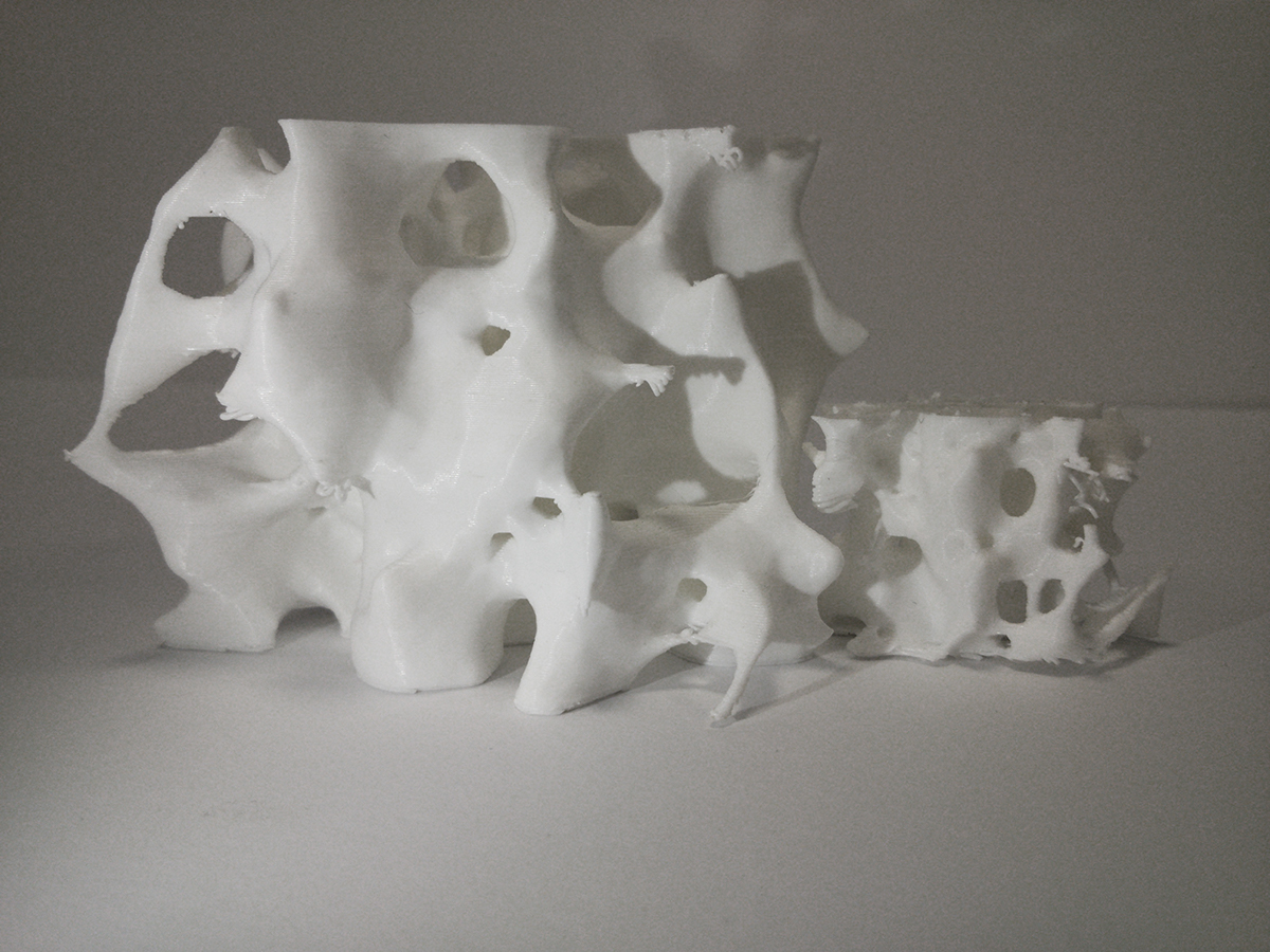
3d print models

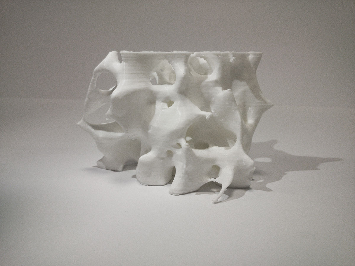
3d print model

3d print model
We experiment on different versions of the same system, which is system 1, and different systems, systems 2 that apply to system 1.
- In the first experimentation, we study gathering and connection in the system, changing the intensities of each behavior.
- We continue the same experiment to create different qualities.
- We then use the trajectories of system 1 and apply system 2 to create geometry.
- In the next experimentation, we add the correlation lines to the trajectories of system 1 and apply system 2 again.
- Until this stage of experimentation the system grows in height, so in order to create spatial qualities in the study area, we change the way of system growth.
- So the next stage of experimentation is on the geometry of the system, because the system is not able to create space.


3d print model, final geometry
We observe that in the last stage of experimentation some spatial qualities of the previous stages have disappeared, so we continue to experiment on geometries. Our intention is to combine the qualities of the first model to the second one.
To achieve this, we use the wireframe of the second model and apply system 2 to this in different ways until geometry reaches desirable spatial qualities.

Going back to the scenario, the goal is to create a new public life pattern using the notions of public and underground space and how the combination of them can offer a sensorium to explore. By sensorium we define the sensorial perception of space that is how the individual experiences space through the sum of senses. So underground space can become a zone of expression and gathering for inhabitants, an exercise in total interiority and the opportunity for reorienting the senses through light, materiality and depth.
Our case study is about spaces, such as gathering place, recreation area, green space, worship space and routes. Each space has different qualities,
- from open collective areas to closed and more private,
- from above-ground to underground areas,
- from seating areas to routes,
- from solid areas to areas that allow light to come in.

Our main concern is how this new public space could be embraced by the introverted society of Istanbul. So our intention is to use underground spaces as a design tool. Furthermore, we add to the design proposal some worship spaces in order to encourage inhabitants to make the new public pattern part of their lives.
These sections are from different models of our experimentation, as an attempt to understand the spatial qualities and their potential to meet the needs of our initial intention.
Returning to our analysis of open green spaces, we decide to locate our project in one of the unused green spaces inside the Theodosian walls, near the housing area and the ice skating hall.

This section shows our intentions and constitutes an attempt to express the difference between the open collective areas and the more private ones. It also shows the way the light comes through to the underground areas in order to avoid darkness and keep connection with the environment.

The picture shows an axonometric view of the 3d model, in which we can see separately the above-ground and underground area.
The above-ground areas are characterized by light, extraversion and discontinuity of geometry,
while the underground areas by shadow, introversion and continuity of geometry.
These differences between above-ground and underground spaces are shown in this perspective section.

Here we can see a total view of the project, just as an intention, in order to appreciate the scale and the relation with its nearby environment.
Morever, regarding to vegetation it sprawls over time and becomes part of the form loosening the boundaries between the natural and the artificial environment.
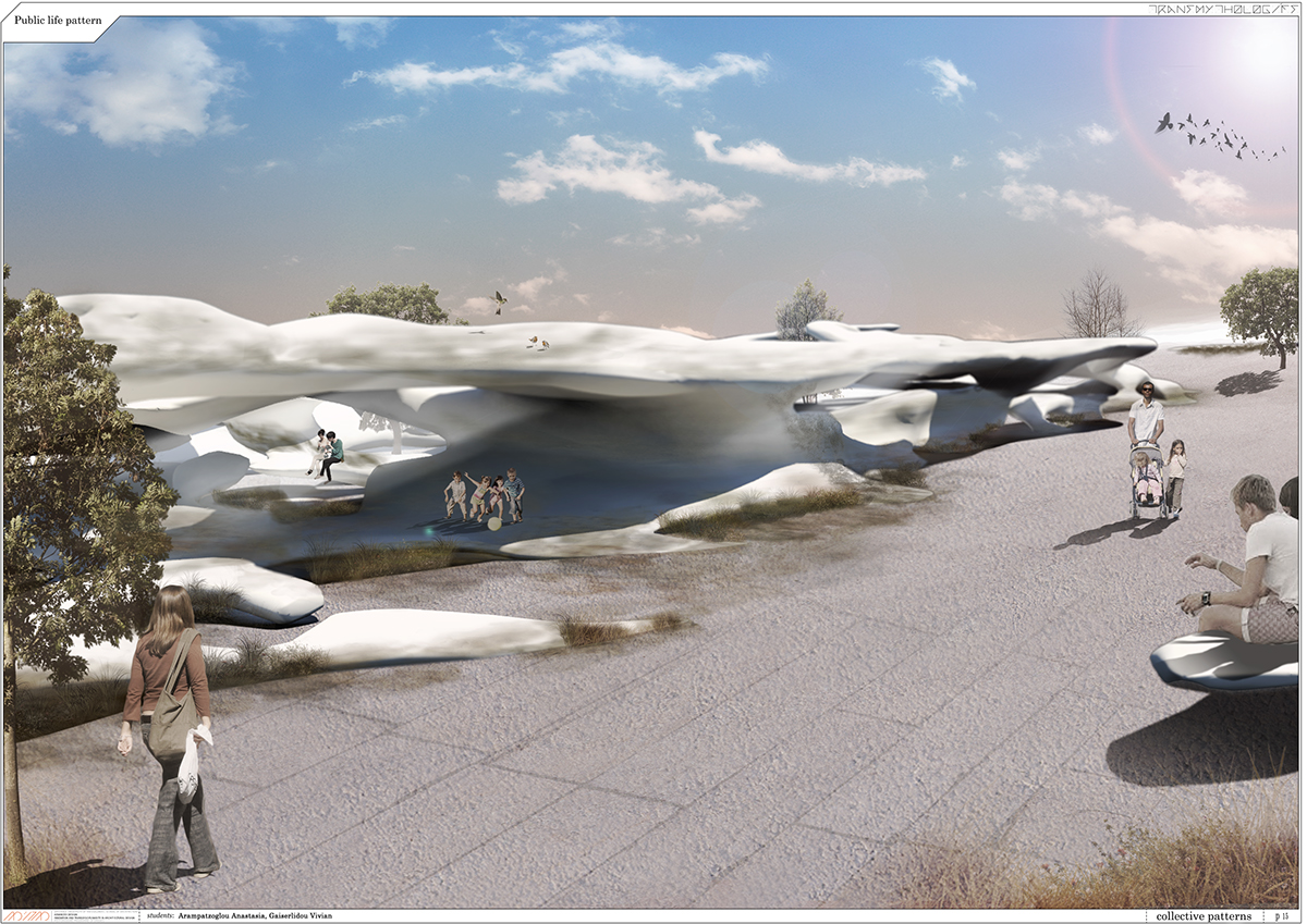
The final picture shows an outside perspective view.
Through our project and the re-appropriation of public space, the intention is to provide a strong “sense of place”, strong identity and character that do not constitute main characteristics of the current public spaces in the study area, but also in the entire city.
